York Outer Ring Road Cost Review and Executive Decision
After the granting of planning approval for the York Outer Ring Road (YORR), a cost review has been undertaken which forms part of a full scheme review, with the aim of updating all the key areas of the project such as the latest anticipated cost, programme, risk and land acquisition against the original business case and funding.
Whilst not conclusive at this time, it is showing that the anticipated cost for the full scheme, A19 to Little Hopgrove Phase 1 dualling, is £163.5million, which was calculated using the AACE International Recommended Practice No 18R-97.
Following completion of the cost estimate, it was evident that there is significant funding shortfall to deliver the Phase 1 dualling scheme.
A total of £52.4 million funding remains to deliver the Phase 1 scheme and so, based on the revised estimate of £163.5 million, this represents a shortfall of £111.1 million.
As a result of this review a report was taken to Executive on the 15 July 2025 for both York Outer Ring Road and the ongoing Station Gateway Project, outlining the issues and proposing options available to the council. It was decided that the Outer Ring Road would be delivered in a phased approach focussing on unlocking wider development and investment opportunities to the city, and £14.55 million of WYCA funding to be utilised in the completion of the Station Gateway Project.
See further details of the YORR Cost Review:
YORR planning application
Following City of York’s planning committee on Tuesday 19 March 2024, and referral to the Secretary of State, the York Outer Ring Road planning application was approved on the 12 April 2024.
Full details can be found on the Planning Access Portal, using the search reference 22/02020/FULM.
- Webcast for Planning Committee A on Tuesday, 19 March 2024
- Agenda for Planning Committee A on Tuesday, 19 March 2024, 2.30pm
- Public Pack Agenda Document for Planning Committee A, 19 March 2024, 2.30pm
The York Outer Ring Road (YORR) scheme, led by the council, aims to:
- improve York’s highway network
- reduce congestion
- facilitate the movement of car journeys out of the city centre
- enhance the pedestrian and cycle experience with improvements to active travel provision along the network
Background and the plan ahead
We'll update this page as the YORR project progresses:
- the need for YORR improvements
- prioritisation of the northern YORR
- enabling works
- planning application
- proposed improvements for pedestrians and cyclists
- landscaping and biodiversity
- our objectives
- impact on city centre traffic flows
- direct engagement with landowners
- public engagement
- construction stages and duration
- sustainable practices
- local employment and skills opportunities
- further information about the York Outer Ring Road Scheme
The need for YORR improvements
The upgrade of the road and the roundabouts aims to reduce congestion and journey times, encouraging traffic out of the city centre and onto larger roads where flows can be managed effectively.
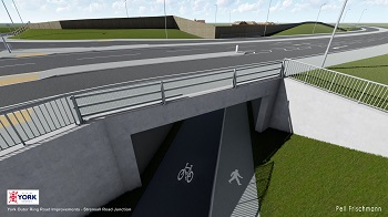
Computer generated image showing the indicative design of the proposed Strensall underpass.
The scheme doesn't propose any 'grade-separation' at junctions for the carriageway, using flyovers and underpasses, as this would be significantly more expensive, and would not be cost-effective due to the prohibitively high cost of the structures involved and extra land required.
We do propose to construct new pedestrian and cycle subways underneath the A1237 as part of these works.
This will be supported by other council projects to improve public transport, cycling, and walking in the city centre, in order to ‘lock in’ the benefits that the YORR improvements will deliver.
Computer generated image showing the indicative design of the proposed Strensall Road junction.
The funding commitment of £42 million by the West Yorkshire Combined Authority (WYCA), £25 million from the Department for Transport, along with additional CYC contributions of £4.5 million.
As reported in January 2025 Executive paper, we're seeking to move £5 million WYCA funding from YORR to York Station Frontage.
York’s draft Local Plan shows where development is anticipated to take place over the next 15 years, including areas set aside for housing and new jobs. Reducing existing journey delays and improving active travel options will help us to manage the extra traffic as more people commute to work and travel to access education, services, and other facilities.
Prioritisation of the northern YORR
The northern sections of the A1237 have been prioritised as the most beneficial to be upgraded at this time, with the largest impact on reducing congestion and delays.
We don't have the level of funding to progress upgrading further stretches of the A1237 to the west of the city, especially the busy sections which cross the River Ouse and the East Coast railway line. This is due to the prohibitive expense of the new structures, such as bridges, required here.
However, we continue to pursue further funding opportunities to help realise the aspiration of full dualling of all of the A1237 in the future.
Dualling of the A64 east of Hopgrove
The A64 is a strategic road (trunk road) and is operated and maintained by National Highways, not the council. Proposals to improve the A64 east of Hopgrove were put forward for funding consideration via the government’s Road Investment Strategy 3 (RIS3) and are under review.
Enabling works
In June 2022, an Executive report was presented to Senior Councillors on the York Outer Ring Road scheme. They agreed to proceed with the procurement and implementation of utility diversions to avoid delays to the future construction phase of the scheme.
These enabling works would allow the full scheme to progress. Diverting utilities at an early stage will help to avoid costly delays to the project.
Planning application
The planning application's aim was to reduce existing congestion, improve active travel facilities for pedestrians and cyclists as well as facilitating the movement of car journeys out of the city centre.
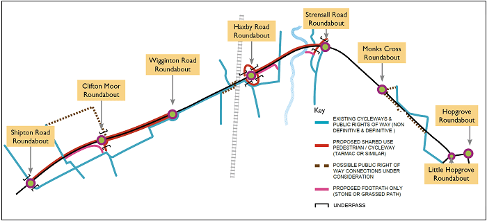
The proposals are for upgrades along the York Outer Ring Road from the A19 Shipton Road to the A1036 Little Hopgrove roundabout and would see improvements to 6 sections of the northern York Outer Ring Road, including 5 roundabouts at:
- Clifton Moor
- Haxby Road
- Monks Cross
- Strensall Road
- Wigginton Road
These 5 roundabouts will be enlarged to a similar size and standard as the A1237/B1224 Wetherby Road roundabout, completed in 2019.
As part of the plans, the existing single-carriageway road will be widened to dual-carriageway roads in both directions to reduce congestion.
Watch some videos about the planning application:
- the Major Projects Manager speaks about York Outer Ring Road planning application
- the Major Projects Manager explains more about York Outer Ring Road proposals
June 2023 updates to the planning application
Updates made to the planning application in June 2023 included:
- An updated review of the cycling provision, in accordance with Local Transport Note 1/20 guidance, which shows that the scheme would provide much improved active travel facilities. The scheme has a Cycle Level of Service (CLoS) score of 82%, exceeding the minimum acceptable overall score (70%).
- Results of the Junction Assessment Tool finding that the scheme provides safe ways to cross the road with underpasses at the Shipton Road, Clifton Moor, Haxby and Strensall Road roundabouts with safe signalised crossings at the Wigginton Road roundabout.
- An updated Biodiversity Net Gain report which continues to demonstrate a comprehensive package of enhancement measures, including planting, screening and habitat creation. Also now included is a recommendation to increase river biodiversity off site.
- Details of the removal of the holding objection from National Highways.
- Responses to the Environment Agency and Internal Drainage Board.
- Slight amendments to drawings and narrative to resolve queries from CYC Highways Development Control.
- Responses to comments from Natural England.
- Responses to comments from CYC Drainage and Ecology Officers.
Further updates were made to the application in December 2023
Following feedback from residents and statutory consultees, the YORR planning application has been updated to provide additional information and clarifications.
In December 2023 updates were made to the planning application including:
- additional drainage information, a revised Drainage Strategy Report and drawings in response to queries raised by the Internal Drainage Board (IDB) and Lead Local Flood Authority
- a new Water Framework Directive Assessment Report, addressing comments raised by the Environment Agency
- amendments to the General Arrangement drawings following consultation with Active Travel England, including improved provision at crossings to accommodate additional turning space for larger cycles
Full details of the planning application can be found on the Planning Access portal, using the search reference 22/02020/FULM.
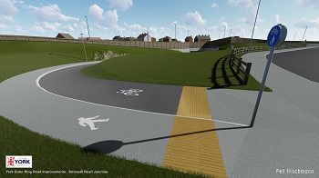
Proposed improvements for pedestrians and cyclists
As an important part of the scheme, we're looking to upgrade pedestrian and cycle facilities, creating an orbital cycle and pedestrian route from the A19 Shipton Road roundabout to the Strensall Road roundabout, to help encourage the uptake of active travel.
The scheme proposes:
- significant additional pedestrian and cycleway networks, creating safe and attractive routes helping to link residential areas with key employment, retail and educational facilities
- retaining and enhancing all public footpaths and bridleways, with some new connections and safer crossing facilities, increasing connections for communities
- a new underpass at Clifton Moor
- 2 new underpasses at Haxby, in addition to the 2 that exist at present
- a new underpass at Strensall Road roundabout
A1237/B1363 Wigginton Road signal controlled crossings
A consultation on the York Outer Ring Road scheme was held in 2020, which identified a need for safer pedestrian crossings.
Data gathered has shown that the number of pedestrians and cyclists travelling between Wigginton Road south and Wigginton Road north across the A1237 is very low, with an average of 25 crossings per day.
Following expert advice, it was decided that controlled crossings would be the best solution based on modelling the demand, land availability and affordability.
Other options such as a bridge or underpass were also considered but ruled out based on cost and environmental grounds.
Specialist software was used to model the effect the crossings will have on traffic. This testing, which considered both morning and evening scenarios, has shown that the crossings can operate safely and acceptably during busy periods.
While the crossings will stop traffic, it's crucial that queues don't affect the main junction's safe operation.
The impact on traffic of the crossing is low; when pedestrians and cyclists use the crossing their 'green light time' is approximately 10 seconds, and traffic is only halted for approximately 30 seconds.
Landscaping and biodiversity
The project includes a comprehensive landscape scheme, retaining existing trees and hedgerows where we can, and looking at opportunities for ‘net gain’ to provide substantial additional tree planting and landscaping along the route. We're aiming to introduce:
- tree and woodland planting
- species-rich hedgerow planting
- specimen trees and feature planting at key locations
- species-rich grassland including wildflowers
- a system of sustainable drainage ditches
The landscaping scheme will incorporate a range of biodiversity measures including planting to benefit pollinators. It will complement the local environment, integrating the new road corridor into the fabric of the existing landscape.
We're also committed to the efficient use of natural resources for carbon absorption and will use energy-saving measures wherever we can to reduce the carbon footprint of the scheme.
Our objectives
The objectives of the scheme include:
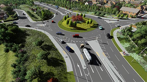
A computer generated example of what one of the roundabouts could look like.
- reduced congestion and delays on the YORR
- provision of active travel networks primarily through delivery of a new continuous cycle and pedestrian route from A19 Shipton Road to Strensall Road with safe connections by underpasses or controlled crossings; this will be a new attractive facility promoting opportunities for cycling and walking in York
- improved safety on the YORR and the reducing of accidents
- facilitating redistribution of through-traffic from York city centre due to the decongestion of the YORR, which will assist in improving air quality
- enable better access to employment, retail, health and leisure sites in York which serve the surrounding population and facilitating planned commercial and residential development identified in key sites in the emerging Local Plan
- enhanced connectivity to the A1(M) and other strategic destinations via the YORR
- enhanced journey time reliability for cross-county movements between origins and destinations in North Yorkshire
- providing an attractive environment and boosting biodiversity within the road corridor through the landscaping scheme
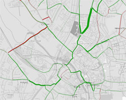
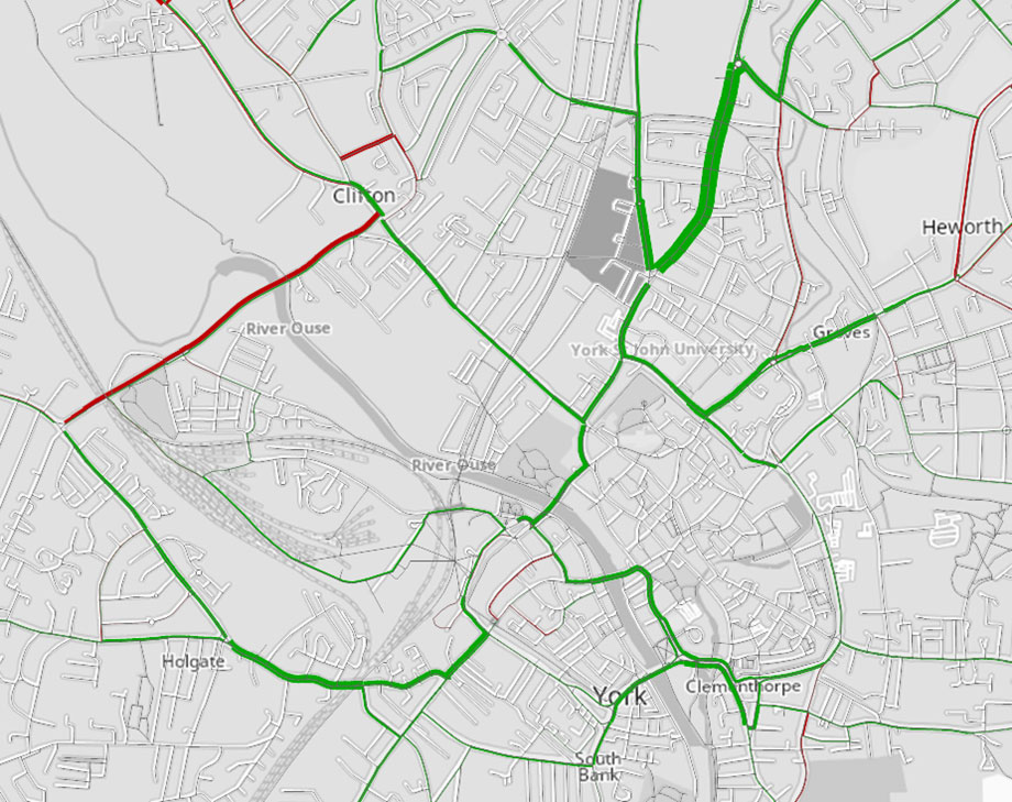
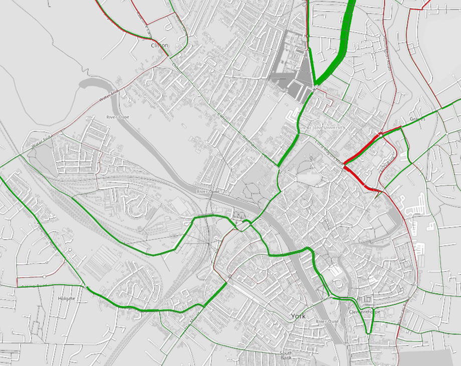
Impact on city centre traffic flows
We’ve forecast the impact on traffic flows in York city centre once the York Outer Ring Road (YORR) Dualling Scheme in place using our strategic Transport Model to compare 2 scenarios, in the year 2025 (with and without YORR scheme), in the morning peak hour and afternoon peak hour.
The 2025 scenarios were used in the Local Plan examination and include planned developments such as York Central and the forecast build of Local Plan sites.
The 2025 scenarios show some reductions in city centre traffic flows (in ‘Passenger Car Units’) with YORR in place.
This creates an opportunity to use the space created by the outer ring road dualling for higher priority transport modes, which will be subject to separate decision-making in the context of the Local Transport Strategy.
Tables of 2025 scenarios traffic flow results
Tables of data show changes where traffic flows have decreased by at least 10% in one peak period (changes lower than 5% are not significant).
Notable decreases (indicated by asterisks*) occur on:
- Gillygate, north-bound
- Haxby Road
- Wigginton Road
- Ouse Bridge
The most significant locations are shown in bold text.
Morning scenario results
| Location | With YORR (A) | Without YORR (B) | Difference (B-A) | Percentage difference |
|---|---|---|---|---|
| Lord Mayor’s Walk, south-bound | 505 | 561 | -56 | -10% |
| Bootham, north-bound | 350 | 411 | -61 | -15% |
| Holgate Road, east-bound | 612 | 682 | -70 | -10% |
| Gillygate, north-bound* | 402 | 454 | -52 | -11% |
| Haxby Road, south-bound* | 454 | 556 | -103 | -18% |
| Haxby Road, north-bound* | 314 | 414 | -101 | -24% |
| Ouse Bridge, west-bound* | 225 | 261 | -36 | -14% |
| Ouse Bridge, east-bound* | 261 | 316 | -55 | -18% |
| Lendal Bridge, east-bound | 430 | 504 | -74 | -15% |
| Blossom Street, north-bound | 704 | 787 | -83 | -11% |
| Crichton Avenue, west-bound | 320 | 369 | -49 | -13% |
| Exhibition Square, north-bound | 429 | 503 | -74 | -15% |
| Monkgate, west-bound | 401 | 425 | -24 | -6% |
| Monkgate, east-bound | 712 | 786 | -74 | -9% |
| Wigginton Road, north-bound | 535 | 595 | -60 | -10% |
| Wigginton Road, south-bound | 545 | 621 | -76 | -12% |
On the map, green lines show decreases in traffic flows, red lines show increased traffic flow.
Afternoon scenario results

| Location | With YORR (A) | Without YORR (B) | Difference (B-A) | Percentage difference |
|---|---|---|---|---|
| Lord Mayor’s Walk, south-bound | 545 | 561 | -16 | -3% |
| Bootham, north-bound | 414 | 426 | -12 | -3% |
| Holgate Road, east-bound | 471 | 514 | -43 | -8% |
| Gillygate, north-bound* | 449 | 530 | -81 | -15% |
| Haxby Road, south-bound* | 477 | 508 | -31 | -6% |
| Haxby Road, north-bound* | 623 | 786 | -163 | -21% |
| Ouse Bridge, west-bound* | 206 | 256 | -50 | -20% |
| Ouse Bridge, east-bound* | 332 | 369 | -37 | -10% |
| Lendal Bridge, east-bound | 532 | 577 | -45 | -8% |
| Blossom Street, north-bound | 595 | 650 | -55 | -8% |
| Crichton Avenue, west-bound | 148 | 134 | 14 | 10% |
| Exhibition Square, north-bound | 524 | 557 | -33 | -6% |
| Monkgate, west-bound | 292 | 329 | -37 | -11% |
| Monkgate, east-bound | 816 | 735 | 81 | 11% |
| Wigginton Road, north-bound | 598 | 606 | -9 | -1% |
| Wigginton Road, south-bound | 768 | 851 | -84 | -10% |
On the map, green lines show decreases in traffic flows, red lines show increased traffic flow.
Direct engagement with landowners
We are engaging with landowners that may be affected by the scheme and we're keen to have discussions with any landowners who are willing to offer additional land for tree planting and landscaping.
Public engagement
A public consultation took place in 2020.
As part of the consultation there was a virtual exhibition to provide residents with an opportunity to learn more about the proposals.
Information packs containing a letter, leaflets and a questionnaire were distributed to members of the public and businesses in specific postcode areas. In addition to this, there was also an online questionnaire which offered residents and businesses the opportunity to provide feedback.
Residents and stakeholders provided over 3,500 comments about the proposals. The consultation was then evaluated.
In September 2021, an Executive report was presented to the Council’s Executive. This provided information on the outcomes of the public engagement. A number of changes were recommended to the Council’s Executive. These changes were approved. Read the Executive Report.
The public engagement highlighted widespread support for the scheme's proposals. 79% of respondents supported the scheme proposals.
Some respondents provided feedback around facilities at some locations for pedestrians and cyclists. Following this feedback, a number of proposals to improve active travel were then included in the scheme.
Construction stages and duration
Subject to the necessary approvals, construction work on the York Outer Ring Road is anticipated to take 2 years to complete.
The scheme involves the construction of a bridge over the York to Scarborough railway line, and another over the River Foss.
The majority of the widening will be constructed to the north of the existing A1237 Ring Road and will be off-highway, which will allow the existing 2-way traffic flow to be maintained for the majority of the construction stage, minimising any disruption to the travelling public.
Further updates relating to construction activities will be provided as the scheme develops.
Order of construction work
The order in which construction will take place will depend upon how the contractor who wins the tender for construction chooses to carry out the works. Much of the widening works will be carried out “offline” without affecting the flow of the existing A1237.
Overnight works
It is anticipated that the majority of the construction work will be carried out during daylight hours, although there will be some work done at night. We'll keep noise and disruption to any nearby properties as low as possible. Access for emergency services will always be maintained.
Sustainable practices
We're committed to sustainable construction practises and will seek to re-use or recycle construction materials and earthworks on-site where possible or seek to re-use materials on other highway schemes across the City. By aiming to divert construction waste which would normally head straight to landfill we could help to reduce costs.
We also aim to utilise green site accommodation, which is better insulated and includes a range of energy saving measures and solar panels.
The planning application and associated Environmental Statement are available to view on the Planning Access Portal, using the search reference 22/02020/FULM.
Local employment and skills opportunities
We aim to support local businesses by using local labour, training, and apprenticeship opportunities wherever possible.
Further information about the York Outer Ring Road scheme
Executive reports and decisions:
- September 2021: Agenda for Executive on Thursday, 30 September 2021, 5.30pm
- June 2022: Agenda for Executive on Thursday, 16 June 2022, 5.30pm
- January 2025: Agenda for Budget Executive on Tuesday 21 January 2025, 4.30pm
Planning meeting:
- Webcast for Planning Committee A on Tuesday, 19 March 2024
- Agenda for Planning Committee A on Tuesday, 19 March 2024, 2.30pm
- Public Pack Agenda Document for Planning Committee A, 19 March 2024, 2.30pm
- Agenda for Planning Committee A on Tuesday 19 March 2024, 2.30pm
- Public Pack Agenda Document for Planning Committee A, Tuesday 19 March 2024 2.30pm

![]()
Also see
York Outer Ring Road - Major Projects Team
Transport Office