Cookie Consent by Free Privacy Policy Generator website
Streets, roads and pavements

Jubilee Terrace to Scarborough Bridge riverside path improvements

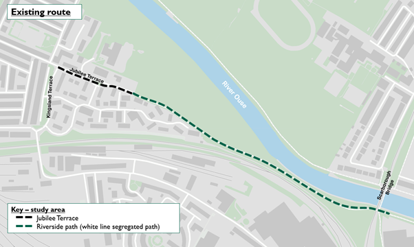
The Jubilee Terrace to Scarborough Bridge riverside path is a key route on the cycle network and is also well used by pedestrians. It connects the west of the city with the city centre and the Scarborough Bridge river crossing.

This project focuses on the section of the path that runs from the junction of Kingsland Terrace and Jubilee Terrace to Scarborough Bridge.

View more information on the Jubilee Terrace to Scarborough Bridge riverside path consultation.

Map showing the current riverside path location, from Kingsland Terrace and Jubilee Terrace to Scarborough Bridge:

A map marking the existing path from Kingsland Terrace and Jubilee Terrace to Scarborough Bridge.

As part of the York Central development, a high-quality pedestrian and cycle route unaffected by river flooding will be provided linking Water End and Leeman Road to Station Rise and Marble Arch.

However, this will not replace the importance of this riverside route to local residents and people who use the path. This is why we are also looking to invest in improvements to the Jubilee Terrace to Scarborough Bridge riverside path.

In May 2023, we successfully secured funding from Active Travel England to deliver improvements to the path.

The council has made up to £600,000 available to support the project, £80,000 of which is subject to further approval. On top of this, the council submitted an Active Travel Fund bid to the government in 2022 for £1.7 million and has now been granted £1.1 million for the improvements. By working with Active Travel England, the overall scope of the project will now be reviewed, but the funds allocated will enable the scheme to progress towards delivery.


Jubilee Terrace to Scarborough Bridge riverside path consultation

This consultation is now closed.

We're currently considering a range of ways in which the path could be improved. This includes:

  • providing improved lighting and security
  • widening or segregating the riverside path, to reduce the likelihood of conflict between pedestrians and cyclists
  • raising the level of the path, in particular at low points, to reduce the impact of river flood events
  • providing more seating and rest areas along the route
  • restricting parking and traffic movement on Jubilee Terrace to reduce conflict between motor vehicles and path users

While we may not be able to deliver all these improvements within our current funding package, this consultation is a key element of understanding how we can deliver the best design possible.

We're engaging with local stakeholders to develop our proposals. This includes the Environment Agency, who we're speaking to about flooding, and Network Rail, whose land adjoins the path.

While we may not be able to deliver all these improvements in our final design within our current funding package, this consultation is a key element of understanding how we can deliver the best design possible. We want to understand the main concerns of local residents and path users to make informed decisions, and will apply for additional funding where necessary.


Current constraints

While the path is currently well used by pedestrians and cyclists, we know that there are a number of barriers to people using the route. There are also a number of physical site constraints that impact what we are able to deliver along the path.

Whole route issues and site constraints include:

  • inconsistent lighting
  • lack of CCTV
  • lack of seating and rest areas
  • existing tree line close to the existing path, which could restrict opportunities to widen the path in some locations
  • the path runs parallel to property boundaries, which could restrict opportunities to change the level of the riverside path - for example, at the ramped access to and from Aldborough Way.

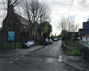
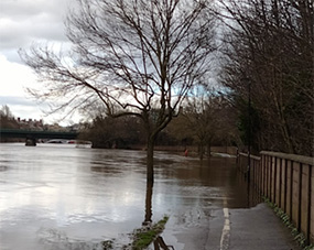
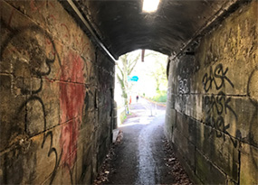
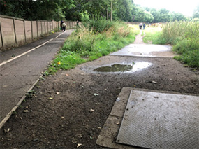
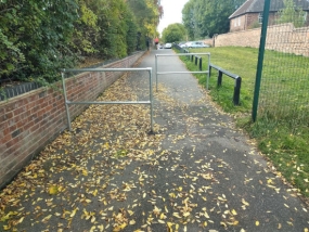
Location-specific issues and constraints are illustrated in the following images:


Creating more space for path users

An important element of improving the path for users will be creating more space for pedestrians and cyclists. We're considering the best way to do this, subject to available funding and being mindful of the identified physical constraints.

We specifically recognise the importance of trees along the path, especially mature trees, and will seek to retain them as far as possible within our design. We'll explore opportunities for replanting or relocating trees should any removals be required.

There are 2 main approaches we are considering to create more space for path users.

Riverside path improvements - approach 1

Widening the existing shared use path, subject to site constraints.

Graphic image of approach 1, showing the existing path at 3 metres wide and the proposed widened path at 4.0 metres to 4.3 metres wide:

Graphic image of approach 1, showing the existing path at 3 metres wide and the proposed widened path at 4.0 metres to 4.3 metres wide.

Map of approach 1 layout, showing a shared-use riverside path running from Jubilee Terrace to Scarborough Bridge:

Map of approach 1 layout, showing a shared-use riverside path running from Jubilee Terrace to Scarborough Bridge.

Riverside path improvements - approach 2

Creating a new parallel path in addition to the existing path so that pedestrians and cyclists can be separated for a significant section of the route, subject to site constraints.

Graphic image of approach 2, showing the existing path at 3 metres wide and the proposed new route with 3 metres, 2-way cycle track, and a separate new 2 metres wide footpath:

Graphic image of approach 2, showing the existing path at 3 metres wide and the proposed new route with 3 metres, 2-way cycle track, and a separate new 2 metres wide footpath.

Map of approach 2 layout, showing the separation of the cycle path track and footpath throughout majority of the route, with segregated path and shared use path towards the Scarborough bridge end:

Map of approach 2 layout, showing the separation of the cycle path track and footpath throughout majority of the route, with segregated path and shared use path towards the Scarborough bridge end.


Other potential improvements

For both the Approach 1 and the Approach 2 options, there are additional elements we are considering to tackle the existing barriers to path use.

Concerns about personal safety when using the path, especially after dark

  • upgrade existing lighting or install new lighting where required, including under Scarborough Bridge
  • install additional low level bollard lighting on a new cycle path, if this approach is chosen
  • install CCTV in key locations along the path

Localised flooding making the path impassable

  • raise path level at localised low points, on both sides of Scarborough Bridge
  • provide better advance warning systems to let people know when sections of the route are likely to be flooded

Whilst raising the path level will not prevent flooding, it is likely to reduce the number of days the path is closed. Based on historic data, currently estimate that this could reduce the time for which the path is closed by about 8 days. However, this is subject to further modelling and investigations.

Parking and vehicle movements on Jubilee Terrace conflicting with pedestrians and cyclists using the path

  • introduce Traffic Regulation Orders to reduce parking space availability
  • improved pedestrian crossings to and from St Barnabas Primary School

Lack of seating and rest areas

  • more seating along the path

Also see

Riverside path consultation

West Offices, Station Rise, York YO1 6GA